In-situ testing represents a cornerstone of geotechnical engineering in Saguenay, encompassing all field-based methods used to evaluate soil, rock, and groundwater conditions directly in their natural state. Unlike laboratory tests that rely on disturbed samples, these procedures measure properties such as density, strength, permeability, and deformation without removing material from its original environment. For a region shaped by glacial activity and post-glacial marine incursions, the reliability of in-situ data is paramount. Engineers depend on these results to design foundations, assess slope stability, and ensure the long-term performance of infrastructure in sensitive clay deposits and variable overburden soils.
The Saguenay–Lac-Saint-Jean area presents unique geotechnical challenges rooted in its Quaternary history. The region is underlain by the Laflamme Sea sediments, which deposited thick sequences of silty clays that can exhibit quick clay behavior when disturbed. These sensitive clays pose risks of retrogressive landslides, a phenomenon well documented along the Saguenay River valley. Additionally, glacial till and fluvioglacial deposits create heterogeneous stratigraphy with abrupt changes in density and grain size. Accurate in-situ characterization is therefore critical to identify potential failure planes, assess liquefaction susceptibility in seismic events, and determine bearing capacity where bedrock is deep or irregular.
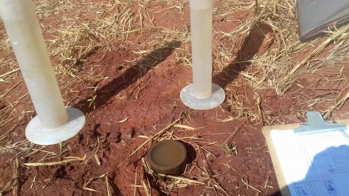
Canadian geotechnical practice follows the standards set by the Canadian Foundation Engineering Manual and provincial guidelines, with testing procedures governed by ASTM International and CSA Group specifications adapted to local conditions. In Quebec, the Code de construction du Québec and BNQ standards often reference these methods while incorporating regional requirements for frost protection and seismic design. For field density verification in earthworks and backfill, the field density test (sand cone method) remains widely specified to confirm compaction levels meet project specifications. Other common in-situ methods include standard penetration testing, cone penetration testing with pore pressure measurement, vane shear testing in soft clays, and pressuremeter tests for deformation modulus determination.
The types of projects requiring comprehensive in-situ investigation in Saguenay are diverse and expanding. Major industrial developments, such as aluminum smelter expansions and port facilities along the Saguenay Fjord, demand precise subsurface models to support heavy foundation loads and deep excavations. Transportation corridors, including upgrades to Route 175 and rail links, traverse areas of complex soil conditions where slope stability and embankment settlement must be carefully evaluated. Municipal infrastructure, from water treatment plants to residential subdivisions in Jonquière and Chicoutimi, relies on in-situ permeability testing for drainage design and soil bearing capacity for cost-effective foundation selection. The region's growing renewable energy sector, particularly wind farm installations on elevated terrain, requires in-situ rock anchor testing and resistivity surveys to optimize turbine foundation design.
In-situ testing evaluates soil and rock properties directly in the ground without removing samples, preserving natural stress conditions, moisture content, and structure. Laboratory testing is performed on disturbed or undisturbed samples extracted from boreholes. While lab tests allow controlled conditions, in-situ methods avoid sample disturbance issues that are particularly critical in Saguenay's sensitive clays, providing more representative measurements of strength, density, and permeability.
For Saguenay's Laflamme Sea clays, field vane shear testing is essential to measure undrained shear strength and assess sensitivity. Cone penetration testing with pore pressure measurement helps delineate stratigraphy and detect quick clay layers. Pressuremeter tests provide deformation parameters for settlement analysis. These methods minimize disturbance compared to sampling and allow continuous profiling through potentially unstable zones where traditional drilling may trigger landslides.
The Code de construction du Québec mandates geotechnical investigations following recognized standards for all buildings covered under its scope. It requires sufficient in-situ testing to characterize bearing capacity, settlement potential, and frost protection depth. For Saguenay, this means investigations must account for the regional frost penetration of approximately 1.5 to 2.0 meters and the potential presence of sensitive soils, often requiring combined in-situ methods to satisfy code requirements for safety and serviceability.
In-situ density testing is required for engineered fills, road base courses, utility trench backfill, and foundation subgrades to verify compaction meets specified density and moisture content criteria. In Saguenay, where freeze-thaw cycles can severely impact poorly compacted soils, testing frequency follows project specifications typically aligned with BNQ or municipal standards. The sand cone method is commonly used for fine-grained soils, while nuclear density gauges may be employed for granular materials to ensure rapid quality control during the short construction season.