← Home · Geophysics

Seismic Tomography Surveys for Saguenay Subsurface Imaging

Together, we solve the challenges of tomorrow.

SEE MORE →

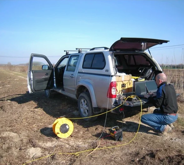
In Saguenay, understanding what lies beneath the surface is not a formality—it is a prerequisite for safe construction. This region sits within the Saguenay Graben, a seismically active rift zone that produced the 1988 M5.9 earthquake, and the variable overburden of glacial and post-glacial sediments demands high-resolution geophysical investigation. We apply seismic tomography, both refraction and reflection, to image subsurface velocity contrasts, map bedrock topography, and identify low-velocity zones associated with faults or fractured rock. Our fieldwork adheres to ASTM D5777 and integrates with NBCC 2015 seismic hazard requirements, providing engineers with P-wave and S-wave velocity models essential for site class determination. The resulting 2D tomographic profiles reveal the geometry of the limestone and shale bedrock beneath the thick Quaternary deposits typical of the Saguenay Lowlands, allowing for informed decisions on excavation depth, foundation type, and seismic design parameters without excessive drilling.

Seismic tomography in the Saguenay Graben reveals the velocity contrast between intact rock and faulted zones, a critical input for any seismic design that cannot be captured by boreholes alone.

Scope of work

Anyone who has worked on the north shore of the Saguenay River knows the challenge: a thin layer of stiff clay overlying a highly irregular rock surface, often with deep glacial troughs filled with soft silt. Our refraction tomography surveys use 24- to 48-channel seismographs with 5 m geophone spacing to resolve these abrupt changes. The method generates a continuous velocity model, highlighting the transition from loose overburden (500–1,200 m/s) to competent rock (above 2,500 m/s). For deeper targets—over 30 m—reflection tomography becomes the tool of choice, mapping stratigraphic boundaries and potential fault planes. Data processing follows a solid workflow: first-arrival picking, traveltime inversion with ray tracing, and waveform validation. This ties directly into seismic microzonation studies where site response depends on accurate shear-wave velocity profiles. Each survey includes GPS-tagged shot points and geophone positions, integrated into CAD or GIS deliverables for the geotechnical and structural design team.
Seismic Tomography Surveys for Saguenay Subsurface Imaging
Technical reference image — Saguenay

Area-specific notes

A 4-storey institutional building in the Jonquière borough encountered a 3 m drop in bedrock over a distance of just 12 m, discovered only after a seismic refraction survey replaced the initial borehole-only investigation. The original design assumed a uniform bearing layer; the reality was a paleo-valley infilled with soft sensitive clay. Correcting the foundation system mid-design would have added months and significant cost. Seismic tomography mitigates this risk by providing continuous coverage between boreholes. In the Saguenay context, another critical factor is fault reactivation: the region’s stress regime can mobilize pre-existing fractures, and low-velocity anomalies on a tomography profile often correlate with these zones. Identifying them early allows the structural engineer to avoid placing heavy columns over potentially unstable ground or to incorporate appropriate reinforcement measures.

Need a geotechnical assessment?

Reply within 24h.

Email: contact@geotechnicalengineering.co

Watch how it works


Reference parameters

ParameterTypical value
Geophone array24–48 channels, 5 m spacing standard
Source typeSledgehammer or accelerated weight drop (AWD)
Depth of investigation15–60 m (refraction), 30–200+ m (reflection)
P-wave velocity resolution±50 m/s in overburden, ±100 m/s in rock
Site class per NBCCVs30 computed from S-wave tomography
Data formatSEG-2, SEG-Y, XYZ velocity grids
Applicable standardASTM D5777-18, ASTM D7400-17
Reporting2D velocity sections, annotated profiles, GIS layers

Linked services


01

P-Wave Refraction Tomography

Ideal for bedrock mapping and rippability assessment. We deploy 24–48 geophones with a sledgehammer or AWD source, generating a 2D velocity model that clearly separates soil, weathered rock, and competent rock.

02

S-Wave Refraction Tomography

Uses a horizontally polarized shear-wave source to measure Vs profiles. Essential for computing Vs30 and classifying the site per NBCC Table 4.1.8.4.A, directly feeding the seismic design basis.

03

High-Resolution Seismic Reflection

Targets stratigraphy and structure below 30 m depth. Applied in Saguenay for fault imaging and deep basin delineation, processed with CMP stacking, deconvolution, and migration.

Standards used

ASTM D5777-18: Standard Guide for Using the Seismic Refraction Method, ASTM D7400-17: Standard Test Methods for Downhole Seismic Testing, NBCC 2015 Division B, Part 4: Structural Design — Seismic Hazard, CSA A23.3-14: Design of Concrete Structures (foundation references)

Quick answers

What is the difference between seismic refraction and reflection tomography?

Refraction uses first-arrival traveltimes from waves that critically refract along velocity boundaries, providing a model of the top 15–60 m. Reflection records energy bounced back from acoustic impedance contrasts, imaging deeper structures (30–200+ m) with higher vertical resolution. In Saguenay, refraction is the standard for bedrock mapping and rippability; reflection is specified when fault delineation or deep basin geometry is required.

How much does a seismic tomography survey cost in Saguenay?

A complete seismic tomography survey in the Saguenay region typically ranges from CA$3,730 to CA$6,180, depending on the array length, number of shot points, and whether P-wave only or combined P- and S-wave acquisition is required. A fixed-price proposal is provided after reviewing the site plan and target depth.

Can seismic tomography replace boreholes on a Saguenay site?

Seismic tomography complements boreholes but does not replace them entirely. The velocity model provides continuous lateral coverage, revealing hidden features like fault zones or abrupt bedrock steps that boreholes can miss. However, a limited number of boreholes or test pits are still advisable to calibrate the velocity-to-lithology relationship and to sample soil for laboratory testing.

Location and service area

We serve projects across Saguenay and surrounding areas. More info.

View larger map